IELTS Task 1 - Pictorial Chart: The Hawaiian island chain
The given graph shows information on the Hawaiian island chain
Write a report for a university lecturer making comparisons where relevant and report the main features.

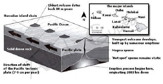
The pictorial chart illustrates the Hawaiian Island chain located in the center of the Pacific Ocean and explains the process of new volcano formations.
The archipelago contains eight significant islands - Niihau, Kauai, Oahu, Molokai, Lanai, Maui, Kahoolawe and Hawaii. The oldest volcano from the chain began to form nearly 80 million years ago. Each island evolved after an eruption on the seafloor, as deep as 2,883 km below the ocean bed. A static 'hot spot' spume pushed magma upwards. Eventually, young volcanoes were formed with the build-up of numerous eruptions.
The Pacific tectonic plate moves in a north-west direction across the Pacific Ocean at a speed of 7-9 cm per year. In a process that takes millions of years, the plate continues to shift slowly and steadily. The eruption process continues to shoot up magma, leading to ongoing eruptions and forming new volcanoes.
Click here to go to the main IELTS Writing Menu


